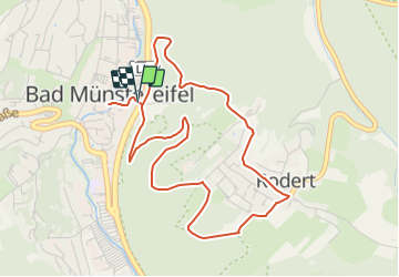
![](/images/other/stat-length.png)
![Trail On foot Bad Münstereifel - EifelSchleife Eselsberg - Photo](https://media.geolcdn.com/t/1900/400/fb2dd39a-4518-4156-8765-a64b7b4bcec8.jpeg&format=pjpeg&maxdim=2)
EifelSchleife Eselsberg
SityTrail - itinéraires balisés pédestres
Tous les sentiers balisés d’Europe GUIDE+
![Length](/images/other/stat-length.png)
![Max alt](https://static1.geolcdn.com/siteimages/upload/files/1508320355ic_sort_altitude_max_24dp.png)
![Uphill gradient](https://static1.geolcdn.com/siteimages/upload/files/1508320355ic_sort_den_pos_24dp.png)
![Km-Effort](/images/other/stat-length.png)
![Min alt](https://static1.geolcdn.com/siteimages/upload/files/1508320355ic_sort_altitude_min_24dp.png)
![Downhill gradient](https://static1.geolcdn.com/siteimages/upload/files/1508320355ic_sort_den_neg_24dp.png)
![Boucle](https://static1.geolcdn.com/siteimages/upload/files/16400158638029165_repeat_loop_refresh_sync_direction_icon.png)
![On foot](https://static1.geolcdn.com/sitytour/trail-icons/100.png)
1h34
Difficulty : Easy
![Scan this QR Code to open this trail in the SityTrail application](https://capi.geolives.com/qq0zvz2zws4bq2lad0pu/sitytour/trails/3102355/qr.png?size=200)
FREE GPS app for hiking
About
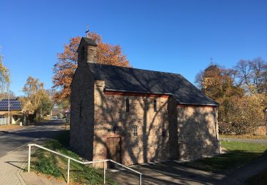
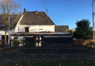
Trail On foot of 4.8 km to be discovered at North Rhine-Westphalia, Kreis Euskirchen, Bad Münstereifel. This trail is proposed by SityTrail - itinéraires balisés pédestres.
Description
Trail created by Nordeifel Tourismus GmbH.
Symbol: quadratisches Logo oben blaue Fläche (Himmel) unten grüne Fläche (Berg/Landschaft), unten bis nach oben auf dem Grünen geschlängelt weiße Linie (Weg), oben links in weißer Schrift „EifelSchleifen“
Positioning
Comments
Trails nearby
![Trail On foot Bad Münstereifel - EifelSchleife Burgenblick - Photo](https://media.geolcdn.com/t/375/260/cbae7020-b35c-4c4b-99e3-7ca353b4b8ca.jpeg&format=jpg&maxdim=2)
![On foot On foot](https://static1.geolcdn.com/sitytour/trail-icons/100.png)
On foot
![](/images/other/stat-length.png)
![](https://static1.geolcdn.com/siteimages/upload/files/16400158638029165_repeat_loop_refresh_sync_direction_icon.png)
![Trail On foot Bad Münstereifel - EifelSchleife Um den Langen Kopf - Photo](https://media.geolcdn.com/t/375/260/037d2424-4eab-4d80-9426-cb1134f1662e.jpeg&format=jpg&maxdim=2)
![On foot On foot](https://static1.geolcdn.com/sitytour/trail-icons/100.png)
On foot
![](/images/other/stat-length.png)
![](https://static1.geolcdn.com/siteimages/upload/files/16400158638029165_repeat_loop_refresh_sync_direction_icon.png)
![Trail On foot Mechernich - EifelSchleife Stockertblick und Herkelstein - Photo](https://media.geolcdn.com/t/375/260/a0b59c05-229a-448d-ada4-df53ccc7f739.jpeg&format=jpg&maxdim=2)
![On foot On foot](https://static1.geolcdn.com/sitytour/trail-icons/100.png)
On foot
![](/images/other/stat-length.png)
![](https://static1.geolcdn.com/siteimages/upload/files/16400158638029165_repeat_loop_refresh_sync_direction_icon.png)
![Trail On foot Mechernich - Wachendorf Rundweg 4 - Photo](https://media.geolcdn.com/t/375/260/36c4d9f8-77e2-49b2-86ee-a878aa6514ba.jpeg&format=jpg&maxdim=2)
![On foot On foot](https://static1.geolcdn.com/sitytour/trail-icons/100.png)
On foot
![](/images/other/stat-length.png)
![](https://static1.geolcdn.com/siteimages/upload/files/16400158638029165_repeat_loop_refresh_sync_direction_icon.png)
![Trail On foot Bad Münstereifel - EifelSchleife Von Sternen und Römern - Photo](https://media.geolcdn.com/t/375/260/db5e9fcc-ec45-4acf-a14c-dd4bd72cb1db.jpeg&format=jpg&maxdim=2)
![On foot On foot](https://static1.geolcdn.com/sitytour/trail-icons/100.png)
On foot
![](/images/other/stat-length.png)
![](https://static1.geolcdn.com/siteimages/upload/files/16400158638029165_repeat_loop_refresh_sync_direction_icon.png)
![Trail Walking Bad Münstereifel - Bad Münstereifel - Photo](https://media.geolcdn.com/t/375/260/ext.jpg?maxdim=2&url=https%3A%2F%2Fstatic1.geolcdn.com%2Fsiteimages%2Fupload%2Ffiles%2F1553511878bg_sport_marche.png)
![Walking Walking](https://static1.geolcdn.com/sitytour/trail-icons/101.png)
Walking
![](/images/other/stat-length.png)
![](https://static1.geolcdn.com/siteimages/upload/files/16400158638029165_repeat_loop_refresh_sync_direction_icon.png)
![Trail Walking Bad Münstereifel - blanken - Photo](https://media.geolcdn.com/t/375/260/ext.jpg?maxdim=2&url=https%3A%2F%2Fstatic1.geolcdn.com%2Fsiteimages%2Fupload%2Ffiles%2F1553511878bg_sport_marche.png)
![Walking Walking](https://static1.geolcdn.com/sitytour/trail-icons/101.png)
Walking
![](/images/other/stat-length.png)
![](https://static1.geolcdn.com/siteimages/upload/files/16400158638029165_repeat_loop_refresh_sync_direction_icon.png)
![Trail Walking Bad Münstereifel - MJW 2-1 - Photo](https://media.geolcdn.com/t/375/260/ext.jpg?maxdim=2&url=https%3A%2F%2Fstatic1.geolcdn.com%2Fsiteimages%2Fupload%2Ffiles%2F1553511878bg_sport_marche.png)
![Walking Walking](https://static1.geolcdn.com/sitytour/trail-icons/101.png)
Walking
![](/images/other/stat-length.png)
![](https://static1.geolcdn.com/siteimages/upload/files/16400158638029165_repeat_loop_refresh_sync_direction_icon.png)